LiDAR Mapping
MTI is proud to use the most effective Aerial mapping tools available. We proudly use the Matrice 300 RTK with the ROCK Robotic R2A.
Topographic/Orthomosaic Mapping:
Orthomosaic Maps are a powerful tool used in a series of industries, allowing users to gather an accurate representation of land calculating a given distance, area or volume. Orthomosaic Maps consist of a series of individual high resolution, low altitude images stitched together using embedded longitude & latitude coordinates to create one high resolution composite image. These images are adjusted accordingly to account for lens distortion and camera tilt. The accuracy is to 5 mm with aerial lidar!
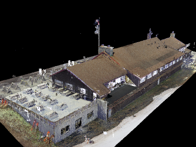
3D Map Reconstruction:
Have you ever wanted to create a 3D image of a building or specific area? With drones, this is now easier than ever! In order to properly create a 3D Map using drones you will need an accurate Geographic Information System (GIS). This system is used to capture, store, manipulate, analyze, manage, and present spatial or geographic data. When creating 3D maps the drone will fly autonomously using preprogrammed waypoints set by the pilot. This is imperative as this will cover 80-90% overlap of a given area which would be extremely difficult for a pilot to perform manually.
Please contact us or call us today for a FREE QUOTE!
or Call us at 518.450.7292


Download our informative
Impact Guide

