Services \
Robotic and LiDAR Services
LiDAR Services
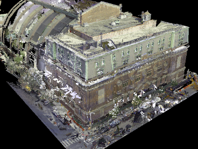
Point clouds are a collection of millions of very accurate dots, that when viewed together create a three-dimensional image of a structure or real-life object or space and much, much more.
The most common use of point clouds is to capture a measurement and create updated drawings of a building. These are then used for designing and managing renovations. MTI Point Cloud data is processed in-house for use in Revit, or other BIM Modeling software, using a Leica RTC 360 scanner to produce different types of 2D drawings and/or 3D models.
Let MTI make your next project a SUCCESS!
Please contact us or call us today for a FREE QUOTE!
or Call us at 518.450.7292
OTHER SERVICES


WANT TO LEARN MORE ABOUT HOW OUR SERVICES CAN FIT INTO YOUR PROJECT'S WORKFLOW?
Download our informative
Impact GuideGET IN TOUCH WITH US
* = Required Field


