Uses of LiDAR systems
LiDAR a helpful tool for all types of Construction.
LiDAR which stands for light detection and ranging is a remote sensing method that is used for measuring the exact distance of an object on the earth’s surface. It has three components, the scanner, laser and GPS receiver. LiDAR was first introduced in the 1960s when laser scanners were mounted to airplanes. It wasn’t until the 1980s after GPS technology was introduced that is actually became popular. LiDAR uses a pulsed laser to calculate an object’s variable distances from the earth’s surface. Using LiDAR systems allows scientists, public safety and construction professionals to investigate natural and man-made environments with both precise measurements to better use the data to benefit their specific project.
We at MTI have researched all the different ways LiDAR is involved in construction needs specifically and the best ways to use it. Although, LiDAR can be used in construction, public safety, transportation, agriculture, geospatial, energy or mining. If you read this article and have any other ways you are using this technology to better your business let us know.
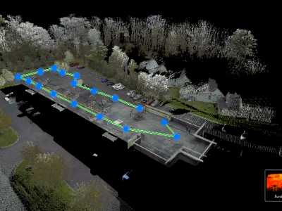
Why are we discussing this? At MTI we have taken a liking to LiDAR technology the last three years. We have invested and used two types of LiDAR terrestrial based and aerial or Airborne based systems. We have the Nextcore RN50 and RN100 Aerial LiDAR we fly on our Matrice 600 and we have the Leica RTC 360 ground-based scanner. The Leica RTC 360 has 3D capability to document and capture 3D environments, improving efficiency and productivity in the field and in the office through fast, simple-to-use, accurate, and portable hardware and software. When we supply our customers with a 3D scan virtual environment for construction it can immensely benefit the project. It can supply architects and engineers with millimeter level accuracy of drawings in existing buildings where drawings may not be available. When they are working on upgrades or additions to the building this can save time and money for all trades so they can identify any potential issues before the building begins.
Airborne LiDAR
Airborne LiDAR is installed on aircrafts like planes, helicopters or drones for data collection. As mentioned, MTI uses our Matrice 600 with Nextcore LiDAR RN50. When it is activated, Airborne LiDAR emits light towards the ground surface which returns to the sensor after hitting the object which produces the exact measurement of its distance. There are two subcategories of Airborne LiDAR- Topological LiDAR and Bathymetric LiDAR. Topographic LiDAR uses a near infrared laser to map the land while Bathymetric LiDAR uses a water penetrating green light to also measure seafloor and riverbed elevations.
Terrestrial LiDAR
Terrestrial LiDAR can be installed on moving vehicles or on the ground with tripods for collecting accurate data points. Terrestrial LiDAR also has two subcategories- Mobile LiDAR and Static LiDAR. We use our terrestrial static LiDAR on a Tripod. The versatility of LiDAR and its high resolution gives it applications in many fields. There are hundreds of uses of LiDAR but here are the ones that can assist with any construction project
1. Digital Elevation Model:
LiDAR has accelerated the process of creating digital elevation models that are used to craft a 3D representation of a terrain’s surface.
2. Micro-Topography:
LiDAR is extremely accurate and can be used to identify details that regular photogrammetry or other survey technology can miss such as surface elevation values that are hidden by vegetation or forest canopy.
3. Bridge Inspection:
Traditional methods of bridge inspection like using a person to climb under and around bridge just for an inspection it’s tricky. Instead, it easily can be executed with LiDAR. The pulses can penetrate bridges to identify potential faults during all phases of construction.
4. Flood Modeling:
Urban flooding is becoming more and more frequent. Buildings, roads and riverbanks all have a notable effect on flood dynamics. LiDAR data provides the advanced topographical information needed to create effective flood relief simulation software.
5. Residential Lighting:
Light levels in our homes and workplaces can make a difference to the way we feel and even affect our health. LiDAR technology is used by residential lighting experts to redirect sunlight, ensuring that enough light reaches all houses within a given area.
6. Terrain Modelling:
LiDAR can offer two types of elevation model: first return and ground forest canopies and buildings (DSM), whereas the second contains only topography (DEM). This is used to create a detailed map of any given terrain.
7. Earthquake Damage:
LiDAR can be used to conduct a post-earthquake assessment of building damage which can expedite the authority’s ability to identify severely damaged buildings quickly.
8.Forest Fire Management:
LiDAR can be used to observe fire patterns and determine high risk areas so measures can be taken to prevent further damage.
9.Solar Energy Planning:
LiDAR can help to identify requirements for solar panel installations.
10.Transport Planning:
LiDAR data helps road engineers to understand the width, elevation and length of the existing road. Road engineers use LiDAR data for things such as: calculating cut & fill, culvert sizing, vegetation removal, grade calculations, height clearances, right of way and surface conditions.
11.Sewer and Manhole Survey:
There are some places in sewer lines that are not accessible physically to humans. In these situations, LiDAR attached to a robotic machine gets sent into the pipe for survey. This information is later fed into the computer for analysis.
12.Urban Municipality:
LiDAR is used by urban municipalities to survey the city. It helps the municipality know where things are and what changes have happened in the city.
13.Road Design:
LiDAR can be used to map out an exact road design which helps create a road free from design flaws and reduces the impact of the new road construction and maintenance.
14.Tunnel Surveying:
LiDAR can be used to get accurate measurements in underground conditions that can be used for analysis, assessment, and modelling.
15.Railway Infrastructure:
Railway track measurement used to be done by a regular survey system. Now LiDAR can quickly perform the measurements of the railway track and the topographical and surrounding area of the railway path.
16.Architecture:
LiDAR can be used to capture a building's structure. This digital information can be transferred to a computer for architecture to design the house model.
17.Lumber Inspection:
Terrestrial LiDAR can provide information on each individual tree dimensions and the overall timber volume of a forest.
18.Building Restoration:
With our ground-based LiDAR we can survey and capture details in building facades with great accuracy. This detail demonstrates the present condition of the building.
19.Virtual 3D Designs:
LiDAR scanning can accurately represent a building and interiors in detail. It offers efficiency, speed and accuracy, it’s becoming widely used in architecture, construction and design. Architects and designers use LiDAR technology to create virtual 3D representations of the projects they want to build.
20.Building Facade Issues:
LiDAR technology is used to collect information about structures and identify potential Issues that are invisible to the naked eye. This data allows contractors to pinpoint where fixes are needed and make adjustments saving time on overall projects.
Works Cited
McNabb, H. (2019, 02 22). 50 Ways to Love Your LiDAR: How LiDAR is Used in Commercial Drone Applications . Retrieved from Dronelife.com: https://dronelife.com/2019/02/22/50-ways-to-love-your-lidar-how-lidar-is-used-in-commercial-applications Sharma, B. (2021, Feb 10). What is LiDAR technology and how does it work? . Retrieved from GeospatialWorld.net: https://www.geospatialworld.net/blogs/what-is-lidar-technology-and-how-does-it-work/Thompson, J. (2019, July 9). 100 Real-World Applications of LiDAR Technology. Retrieved from Level Five Supplies: https://levelfivesupplies.com/100-real-world-applications-of-lidar-technology/


