Topographic Surveys/Orthomosaic Maps
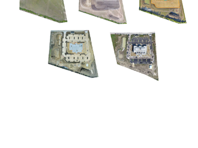
Site Progression Orthomosaic Mapping
An orthomosaic map is one large high resolution image composed of hundreds of lower elevation images stitched together. The creation of this map is possible, due to geo-reference points being stamped every time an image is taken using an MTI payload.
An orthomosaic map can be used to calculate accurate area, volume, distance and slope measurements. While utilizing this map, you’ll also have the ability to overlay blueprints and drawings from ProCore to compare design versus the build reality.
When safety is paramount nothing helps analyze job site hazards like the perspective an aerial reconnaissance. Drones are an affordable alternative to helicopters, planes and other sources of aerial data.
Please contact us or call us today for a FREE QUOTE!
or Call us at 518.450.7292


Download our informative
Impact Guide


